Progress Report
Artificial generation of upstream maritime heavy rains to govern intense-rain-induced disasters over land (AMAGOI)[8] Damage Estimates
Progress until FY2024
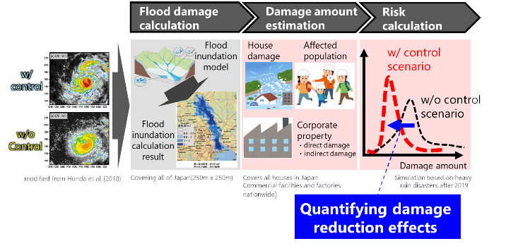
1. Outline of the project
In this research item, we develop a methodology for estimating the effect of weather control on reducing economic damage (Fig.1). Specifically, we are developing; 1) a flood and inundation simulation model for the entire Japan for calculating the inundation area and its depth in the cases with and without weather control; 2) an exposure asset database based on various statistical data and a flood economic damage estimation model based on inundation depth and exposure information, and 3) a risk estimation model of landslide disasters triggered by heavy rainfall events. By utilizing the developed models, we aim to quantify the effect of weather control on reducing economic damage.
2. Outcome so far
[Runoff-Inundation Modeling with in-situ infra.]
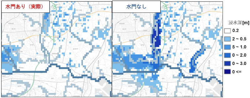
Japanese river channels have been continuously modified and changed by levee construction, dredging, and installation of artificial facilities.
In FY2023 and FY2024, we developed 1) a nationwide database of confluent sluice gates, 2) a nationwide database of pumping stations at the confluents, and 3) a nationwide database of non-continuous levees, based on satellite images and documents by facility managers, and then we introduced the databases in the nationwide flood and inundation model.
Also, we applied the runoff parameter calibration method, which is robust to the multi-point and multi-event, and determined the runoff parameter which is spatially consistent (Fig.2).
[Exposure Asset and Damage Function Database]
In FY2023, we built an exposure asset database for entire Japan, which consists of population, private assets, and the properties related to the indirect loss, by combining the statistics by the government and several private companies. In FY2024, we reviewed the depth-damage functions, which calculate the damage ratio of each asset type based on the inundation depth. Using the flood and inundation disaster of Kinu River in 2015, we optimized the thresholds of the depth-damage function, and selected the best candidate for each asset type.
[Landslide Risk Model Development and Application]
We implemented the SLIP model, physics-based model for landslides, and the logistic model, probabilistic risk evaluation model. Using the landslide disaster of Hiroshima in 2014 as an example, we verified their performance. In addition, based on the result of weather modification from research item 5, we showed that the landslide hazard in the target area will be decreased by the weather modification (Fig.3).

3. Future plans
For the flood damage estimation, we will focus on the selected target area and execute the model performance verification with multiple flood disasters. For the landslide risk estimation, we develop the combined methodology of physics-based model and probabilistic risk evaluation model.