Project on Risk Identification and Land-use Planning for Disaster Mitigation of Landslides and Floods in Croatia
Principal Investigator
ODA Recipient Country
Republic of Croatia
Research Institutions in Japan
Niigata University / International Consortium on Landslides (ICL) / Kyoto University
Research Institutions in Counterpart Country
University of Split (UNIST) / University of Rijeka (UNIRI) / University of Zagreb (UNIZAG)
Adoption fiscal year
FY 2008
Research Period
5 Years
Overview of the Research Project
Japan provides assistance for problems resulting from unique topography and Geology
Croatia is in a region with a concentration of ground strain, and with a complex topography and geological structure. For this reason, earthquakes occur frequently, as do landslides and localized flash-floods. Accordingly, Japanese science and technology - which leads the world in the field of disaster mitigation - is being applied to Croatia in research aimed at mitigating landslides and floods. Specifically, this project focusses on disaster mitigation in developing regions and places with significant societal value and promotes the establishment of landuse planning policies to mitigate disasters.
Accurate recognition of natural conditions in the country and development of useful tools
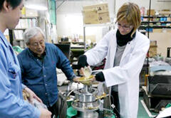
As specific achievements, a comprehensive movement monitoring system was installed in representative landslide areas and an early warning system was arranged. In addition, the prototype of a “landslide reproducing test apparatus” that is effective in predicting the travel distance of sliding soil mass was developed. Furthermore, the endangered areas by landslide and flood disasters were classified by site characteristics in an effort to support to carrying out sustainable development of the territory.
Photo gallery

Use of a 3D laser scanner to measure the location of rock blocks with a high risk of collapse that are scattered across the steep slopes of the Adriatic coast (example of measurements made in Du?e, on the outskirts of Split)
Research Project Web site
Press Release
Links
Projects
Contact Us
Japan Science and Technology Agency (JST)
Department of International Affairs
SATREPS Group
TEL : +81-3-5214-8085
Related articles by Category
- Disaster Prevention and Mitigation
Disaster Prevention and Mitigation

 Kingdom of Tonga
Volcanic island nations working together to reduce the risk of eruption and tsunami disasters!
Disaster Risk Reduction of Widespread Volcanic Hazards in Southwest Pacific Countries
- Europe
Environment / Energy
(Global-scale environmental issues)
 Republic of Kazakhstan
Aim for zero pollution by digitizing mines with “Smart Mining Plus”!
Next-generation Smart Mining Plus for Sustainable Resources Development
- SDGs : Goal.11
Environment / Energy
(Carbon Neutrality)
 Kingdom of Thailand
Mobilizing data and models to help reduce traffic congestion in Bangkok!
Data Driven Dynamic Transport Management in Emerging Metropolis for Climate Change Mitigation


 Republic of Croatia


