Research Results
Highly accurate precipitation forecast updated every 30 seconds
Early prediction of guerrilla rainstorm riskFY2021

- Miyoshi Takemasa (Team Leader, Data Assimilation Research Team, RIKEN Center for Computational Science)
- CREST
- Advanced Application Technologies to Boost Big Data Utilization for Multiple-Field Scientific Discovery and Social Problem Solving "Innovating “Big Data Assimilation” technology for revolutionizing very-short-range severe weather prediction", Research Director (2013-2019)
- AIP Acceleration Research
- “Big Data Assimilation and AI Creating New Development in Real-time Weather Prediction'', Research Director (2019-2021)
Predicted guerrilla rainstorms that develop in minutes
The team under Miyoshi Takemasa, who is the research director of the AIP Acceleration Research, has developed an ultra-high-speed rainfall forecast system to predict a rainfall such as a guerrilla rainstorm for the next 30 minutes. In this system, new data is acquired and updated every 30 seconds in real time using detailed observation data of rain clouds every 30 seconds by state-of-the-art, multi-parameter phased array weather radar (MP-PAWR) operated by the National Institute of Information and Communications Technology and the supercomputer "Oakforest-PACS" of the HPC infrastructure facility (JCAHPC). The data predicted here is continuously displayed on the website of RIKEN's weather forecast study, divided by units of 30 seconds.
From August 25 to September 5, 2020, a real-time, experimental demonstration of an ultra-high-speed rainfall forecast for the next 30 minutes was conducted for the Tokyo metropolitan area, which was updated every 30 seconds.
This study result is an extension of the CREST "guerrilla rainstorm prediction method" utilizing the "K” supercomputer and phased array weather radar (PAWR) in 2016, and is a culmination of various achievements that have been made since 2013. Rainfall forecasts calculated by linking the virtual world and the real world on a computer can now be updated at orders of magnitude faster than previous weather forecasts, and it is also possible to predict heavy cumulonimbus rain clouds which develop rapidly into guerilla heavy rainfalls within a few minutes.
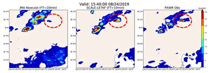
Fig. 1: Rainfall intensity distribution at 15:40 UTC on August 24, 2019 (0:40 am on 25th, Japan time). Compared to the 10-minute forecast of the Japan Meteorological Agency's high-resolution precipitation nowcast (left), the 10-minute forecast of the forecast system of this study (middle) is similar to the one actually observed by MP-PAWR (right).
Toward highly-accurate real-time precision
Recently, locally-limited sudden guerrilla rainstorms have been increasingly observed. Since guerrilla rainstorms have great influence on daily lives and social economy, and in some cases, cause disaster in which human lives were lost, the technology that predicts the generation of guerrilla rainstorms is increasingly required.
Currently, the local model operated by the Japan Meteorological Agency is capturing new observation data every hour with a resolution of 2 km for the whole country. However, cumulonimbus clouds that cause guerrilla rainstorms occur in just a few minutes and develop rapidly, making them difficult to predict with current weather forecasts, and resolutions broader than one kilometer cannot adequately resolve such clouds.
Therefore, in 2016, Miyoshi et al. combined a high-definition simulation with a resolution of 100 meters using the “K” supercomputer and high-speed, big data obtained from phased array weather radar to make “weather forecasts for the next 30 minutes, updated every 30 seconds with a resolution of 100 meters", which are effective for guerilla rainstorms. This method was spatially and temporally more accurate than the previous weather forecasts, but due to the huge amount of data handled, although the calculation had to be completed within 30 seconds, it took about 10 minutes. In other words, although this method could achieve high prediction accuracy, it was not possible to process the data sent every 30 seconds in time, nor to operate it in real time.
Therefore, the study group has been working on various technical issues to realize real-time prediction.
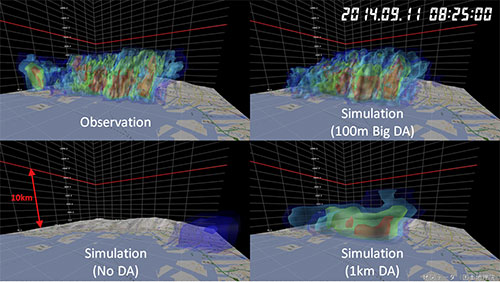
Fig. 2: Distribution of rain clouds near Kobe City at 8:25 am on September 11, 2014. The upper left is actual rain cloud observation data, and the upper right is the predicted data with a resolution of 100 m. It can be seen that the actual appearance of rain clouds is reproduced better than by the conventional prediction using data with a resolution of 1 km.
https://www.jst.go.jp/pr/announce/20160809-2/index.html
Achieved high-speed calculation and high-precision forecasting
It is necessary to significantly reduce the calculation time in order to perform real-time prediction. Miyoshi et al. devised ways to suppress the input and output of large-scale data on supercomputers, and speeded up the calculation of prediction models. As a result, the calculation time, which took about 10 minutes before, was reduced to about 20 seconds, and the speed was increased by about 30 times.
In addition, the entire system was ported so that the supercomputer "Oakforest-PACS" jointly operated by Tsukuba University and the University of Tokyo could be used instead of the "K” computer, improving the versatility of the entire system.
A data acquisition software was also developed which immediately transfers observation data of the new MP-PAWR installed at Saitama University in 2017 to Oakforest-PACS. In addition, a workflow for real-time forecasting was constructed in which four types of forecast areas with different resolutions were nested. Here, the results of the global digital weather forecast system of the US National Environmental Forecast Center were acquired in real time, and used as lateral boundary values (numerical values of meteorological variables).
The resulting ultra-high-speed forecast system uses simulations that take account of meteorological mechanisms such as cloud formation, development, thinning and disappearance, so it can grasp sudden changes in guerrilla rainstorms that cannot be captured by the system currently used by the Japan Meteorological Agency. Hence, it is now possible to predict the strength of rain clouds as observed by the actual MP-PAWR.
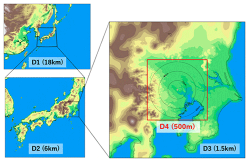
Fig. 3: Calculation area in simulation with quadruple nesting.
D1 (resolution 18 km) in the upper left figure nests D2 (resolution 6 km) which in turn nests D3 (resolution 1.5 km) in the right figure. D3 also nests D4 (resolution 500 meters) as shown by the red frame in the right figure. With this setting, the forecast of the innermost area D4 is updated every 30 seconds.
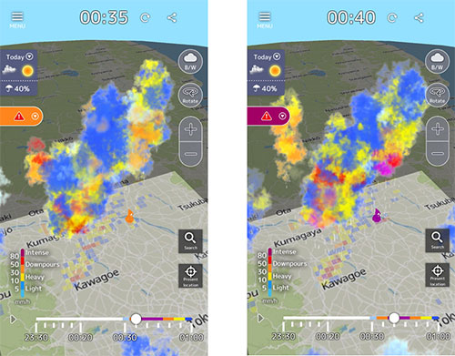
Fig. 4: Smartphone app, "3D Amagumo Watch"
Forecast data is open to the public on a smartphone app with forecast business permission based on the Meteorological Service Act. It forecasts rain clouds that develop rapidly from heavy rain (orange) to torrential rain (purple) in just five minutes.
The app can be found and obtained at https://pawr.life-ranger.jp/.
In addition to disaster prevention, application to the environment and fisheries fields is expected
In future, by analyzing and verifying the results of demonstration experiments, it will possible to accelerate ultra-high-speed, ultra-high-definition prediction of guerrilla rainstorms, which was previously impossible. If the advent of guerrilla rainstorms is known in advance, even immediately beforehand, it is possible to take measures such as evacuation, which can contribute to constructing a disaster prevention system and mitigating the disaster damage.
Moreover this research, which combines the virtual world simulated by a computer with the real world of values measured by radar, is also a good example of the super smart society, Society 5.0. Apart from meteorology, this may be applied to environmental fields such as forecasting changes in forests, and fisheries such as predicting the behavior of tuna and the red tide.