Research Results
Preparing for the risk of a massive earthquake and tsunami off the coast of Mexico
Major contributions to disaster prevention and mitigation beyond national bordersFY2023

- ITO Yoshihiro(Associate Professor of Disaster Prevention Research Institute, Kyoto University)
- SATREPS
- Principal Investigator (2015-2022), "Hazard Assessment of Large Earthquakes and Tsunamis in the Mexican Pacific Coast for Disaster Mitigation"
- aXis
- Principal Investigator (2020-2022), "Applications and demonstrations of Japanese ocean bottom observation system and culturally-tuned disaster education program"
Challenging earthquake-prone areas in Mexico
Mexico, roughly 10,000 km away from Japan, is known as an earthquake-prone country like Japan. The land of Mexico sits on the North American Plate (bedrock), with the western Pacific side of the country in a subduction zone, where the Cocos Plate subducts under the North American Plate from the Pacific Ocean side. Consequently, it is one of the areas in the world with the highest risk of large-scale subduction earthquakes*1, or megathrust earthquakes and associated tsunamis. Therefore, earthquake and tsunami disaster prevention efforts have long been recognized as an important challenge.
The project team built a Global Navigation Satellite System (GNSS) and a seismic monitoring network on land and seafloor around the Guerrero seismic gap (area where no earthquake has occurred for the past 100 years) in the State of Guerrero on the Pacific coast of the United Mexican States (Fig. 1) in collaboration with the National Autonomous University of Mexico, etc., to analyze the crustal activity records. The results revealed a link between three major earthquakes that occurred in Mexico in 2017-2019 (Fig. 2) and slow slips*2.
It also identified for the first time the occurrence of a slow earthquake*2, also in the Guerrero seismic gap. The observed slow seismic activity accounts for the fact that the seismic gap has weaker interplate coupling*3 than its surroundings, and that earthquakes centered in the gap are less active than those in its surroundings. In addition, the risk of a massive earthquake that had been anticipated to occur in this region was shown to be lower than had been previously assumed.
*1 Subduction earthquake
An earthquake that occurs around an ocean trench located at the boundary between an oceanic plate and a continental plate. Subduction earthquakes include earthquakes caused by the slip between an oceanic plate and a continental plate (interplate earthquakes), and those caused by the destruction of an oceanic plate (intraslab earthquakes).
*2 Slow earthquake/slow slip
A slow earthquake is a phenomenon that releases distortion at a slower fault-slip velocity than a ordinary, or fast earthquake. Depending on its size (or duration), it is called
· a slow slip event(magnitude five or higher)
· a very low-frequency earthquake (magnitude three to four)
· a low-frequency earthquake/tremor (magnitude two or lower)
A slow slip event can last from a few days to a year or longer. A slow slip event was also observed shortly before the 2011 off the Pacific coast of Tohoku earthquake. Areas where slow earthquakes have been carefully monitored and studied include Mexico, the Nankai Trough, New Zealand, South America, and the Pacific coastline near the U.S.-Canada border.
*3 Interplate coupling
This refers to a coupling at the boundary between a continental plate and an oceanic plate. The degree of the coupling varies with location and depth. The stronger the coupling, the more distortion accumulates as the continental plate is pulled in, releasing it all at once and triggering a massive earthquake. Conversely, the weaker the coupling, the less distortion accumulates as the continental plate smoothly subducts, inducing slower earthquakes such as low-frequency earthquakes and slow slips.
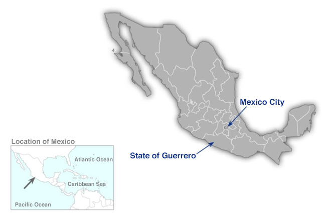
Fig. 1 State of Guerrero, Mexico, on which the study focused
The magnitude-8.2 Tehuantepec earthquake on September 8, 2017, the magnitude-7.1 Puebla earthquake on September 19, 2017, and the magnitude-7.2 Pinotepa earthquake on February 16, 2018, occurred in the vicinity of the State of Guerrero.
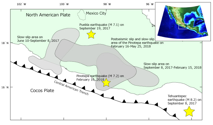
Fig. 2 Area where the three massive earthquakes occurred
Three major earthquakes that have shown clear interaction (at the locations marked by ★) and the slow-slip areas (in gray). The Cocos Plate subducts under the North American Plate from the Central American Trench in these areas.
Challenges in reducing the risk of massive earthquakes and tsunamis
The western Pacific side of Mexico is the region with the highest risk of megathrust earthquakes and tsunamis in the world, with repeated major earthquakes occurring at the plate boundaries.
While major earthquakes frequently occur in the State of Guerrero in southern Mexico, there is an area of seismic blank, called the Guerrero seismic gap, where no major earthquakes have occurred in the past 100 years. Future earthquakes in this area are expected to be of magnitude 8, making it a highly alarming region for earthquake and tsunami disasters. However, this has not been fully understood because there have been no seismic monitoring stations on the seafloor to date.
Mexico is preparing to develop an early tsunami warning system (SINAT), mainly using land-based monitoring networks, as a countermeasure against earthquake and tsunami disasters. However, the lack of observational data has prevented the establishment of a highly reliable earthquake/tsunami model. In addition, fewer researchers in seafloor seismology/geodesy, coastal engineering and tsunami research and less information accumulated on tsunami disasters make the public less aware of tsunamis. As a result, concrete measures to mitigate tsunami disasters had not been fully implemented.
There has been a need to resolve these issues, develop scenarios and models for megathrust earthquakes and tsunamis, and conduct R&D and social implementation to reduce damage from future massive earthquakes and tsunamis.
Mechanisms of slow earthquakes beginning to be understood
Continuous displacement data from 57 GNSS monitoring stations, including those located in the State of Guerrero, were analyzed in this project as a joint international observation by Japan and Mexico (Fig. 3). The rate of slow slip at the boundary between the Cocos and North American plates, the postseismic slip*4 after a major earthquake, and the interplate coupling ratio*5 over time were determined.
The analysis showed that the three major earthquakes that occurred in Mexico in 2017-2018 were a chain of events triggered by interactions with slow slips occurring in the vicinity of those earthquakes. In other words, the three consecutive major earthquakes were induced by the interaction of a major earthquake and slow slips.
The study of the Guerrero seismic gap was also successful in detecting for the first time the waveforms of small-scale slow earthquakes (tectonic tremors) in the area.
There have been two different theories interpreting the Guerrero seismic gap. The first theory is that the seismic gap is a strong coupling region that has been accumulating distortions caused by the plate subduction over at least the past 100 years. The second theory is that the seismic gap is a weak coupling region where the distortion caused by subduction due to frequent slow earthquakes is released. The observation results of this project are almost consistent with the second theory, indicating that the probability of a magnitude 8 earthquake is not as high as previously assumed. The results of the present study provide a reason why no major earthquakes have occurred in the Guerrero seismic gap for a long time (Fig. 4).
Note, however, that the 2011 off the Pacific coast of Tohoku Earthquake was an example of a slow earthquake zone turning into the epicenter of a massive earthquake. Efforts for earthquake and tsunami disaster prevention in the Guerrero region need to be continued.
The other program, "applications and demonstrations of a Japanese ocean bottom observation system and culturally-tuned disaster education*6," was simultaneously implemented to "reduce earthquake and tsunami damage in Mexico and contribute to achieving the SDGs." The timing of the project coincident with the Covid disaster made it difficult to carry out sufficient activities due to severe restrictions.
Nevertheless, applications and demonstrations are steadily progressing through various ideas of researchers, such as remote surveys which were required because of the Covid disaster, and the results can contribute significantly to disaster prevention in the partner country in the future.
Some contributions to the achievement of the Sustainable Development Goals (SDGs), such as the development of tsunami evacuation scenarios and the presentation of safe evacuation routes from tsunamis, have been recognized. Currently, however, all of these goals are close to being achieved, and the Mexican side is now expected to make independent efforts.
*4 Postseismic slip
An area that keeps slowly slipping after the quake where it slipped.
*5 Interplate coupling ratio
The higher the degree of coupling (coupling ratio) at the boundary between continental and oceanic plates, the greater the distortions that accumulate. The value of the coupling ratio is determined by the ratio of the "speed at which the continental plate is pulled in" to the "speed at which the subducting oceanic plate is moving."
*6 Applications and demonstrations of Japanese ocean bottom observation system and culturally-tuned disaster education program
A project organized by JST to contribute to the achievement of the SDGs in developing countries by utilizing scientific and technological innovations from Japan, and to promote the overseas deployment of research results, etc., from Japan. Efforts to solve social issues in partner countries through this project are expected to promote sustainable development while contributing to the establishment of positive cooperative relationships between Japan and the partner countries.
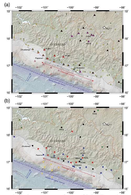
Fig. 3 Land and seafloor seismic/geodetic monitoring network installed in this project
(a) Seismic monitoring networks [Cruz-Atienza et al., Seismological Research Letter, 2018]
Red triangles represent the broadband seismic monitoring network installed in this project, and pink triangles the seafloor seismographs. Other triangles represent the pre-existing seismic monitoring network.
(b) Geodetic monitoring network
Red circles represent GPS monitoring stations installed in this project, pink circles seafloor crustal deformation monitoring stations using GPS/A, and yellow inverted triangles seafloor pressure gauges.
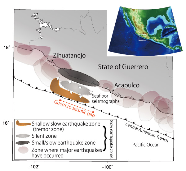
Fig. 4 Shallow slow earthquake zone, silent zone and small/slow earthquake zone in the Guerrero seismic gap
The Guerrero seismic gap includes the shallow slow earthquake zone (area where tectonic tremors occur), the silent zone (area where no earthquakes occur), and the small/slow earthquake zone. The interplate coupling is weak in the silent zone, likely to move slowly and constantly slipping. There is also the possibility that the silent zone corresponds to the concave portion of the plate boundary. This study suggests that the region with weak coupling may extend from the trench to near the coastline in the Guerrero seismic gap.
Aiming for disaster prevention and mitigation in Mexico and Japan
Earthquake and tsunami scenarios were developed in this project based on the latest observation data in the Guerrero seismic gap. The purpose was to conduct a risk assessment and disaster mitigation education in the State of Guerrero, to provide hazard information and educational materials for disaster mitigation to those involved in disaster prevention, and to support the continued development and implementation of tsunami evacuation guidelines and disaster mitigation education.
These comprehensive approaches are in line with the development policies and needs of the Mexican government, and thus their implementation has been highly regarded.
Understanding the similarities and differences of slow earthquakes and massive earthquakes in Mexico will also be useful for Japan in understanding the essential nature of possible massive earthquake and tsunami disasters that may occur in the Nankai Trough*7. The efforts to address the challenges of mitigating disasters caused by massive earthquakes have led to research results that will help to realize the sustainable development of a society that protects the lives and property of citizens from possible future earthquake disasters.
*7 Trough
Among elongated groove-shaped geographical features on a deep seafloor, one with relatively steep slopes on both sides that is 6,000 m or more in depth is usually called a trench, whereas one that is shallower and wider than a trench is called a trough (boat-shaped ocean basin). The Japan Trench, Chishima Trench and Izu-Ogasawara Trench formed by the subduction of the Pacific Plate, as well as the Nansei-Shoto Trench, Nankai Trough, Suruga Trough and Sagami Trough formed by the subduction of the Philippine Sea Plate, surround Japan.