Research Results
Combining simulation and observed values
Early forecast of typhoons and torrential rainFY2019

- Takemasa Miyoshi(Team Leader, RIKEN Center for Computational Science)
- CREST
- Advanced Application Technologies to Boost Big Data Utilization for Multiple-Field Scientific Discovery and Social Problem Solving "Innovating "Big Data Assimilation" technology for revolutionizing very-short-range severe weather prediction" Research Director (2013-2019)
- AIP Acceleration Research
- ”Big Data Assimilation and AI Creating New Development in Real-time Weather Prediction” Research Director (2019-2021)
High precision was achieved with “K computer” and “Himawari-8”
In recent years, there have been unprecedented violent weather-related disasters as the global climate changes. A research director of CREST, team leader Takemasa Miyoshi and others developed a method to rapidly predict changes in weather with high precision by data assimilation, in which the simulation by the Japan's flagship supercomputer “K” and observed values from the weather satellite “Himawari-8” and high resolution weather radar are combined.
Weather satellite Himawari-8 began its operation in July 2015. Compared to Himawari-7, observation performance has dramatically improved, and the frequency at which the whole Earth is imaged increased from once an hour to once every 10 minutes. In addition, the performance of the sensor improved, and the amount of data has increased by 50 times. By processing this big data with “K computer”, rapidly developing typhoons and localized torrential rain that were difficult to predict in the past could be predicted at an earlier time at higher precision.
To predict more localized weather changes, the phased array weather radar (PAWR) with multiple antennas on one board is used. The PAWR was first installed on Suita campus of Osaka University in 2012. Dividing the central area of Keihanshin region (radius of 60 km) into 100-m grids, the data are sent to the PAWR every 30 seconds. The scale of a single cumulonimbus cloud that causes localized heavy rain and tornados is small at several km, and was difficult to predict with traditional simulations with a grid spacing of 2 x 2 km. But, in the simulations with a grid spacing of 100 x 100 m using PAWR, weather change in a narrow area can be captured in detail.

Supercomputer K and team leader Miyoshi.
Tackling difficulties of prediction
Typhoons and torrential rains cause serious damage such as flooding and landslide. To reduce such disaster, prediction and preparation are important. The need for prediction for torrential rains is increasing. Since such a weather change occurs suddenly in a narrow area, prediction is difficult. Team leader Miyoshi and others tackled this problem.
Presently, weather forecast is based on simulation using a supercomputer, and simulation results are compared with actual observation using a high-precision weather radar or weather satellite at a certain interval. In this way, its track is corrected. By increasing the precision of this data assimilation, if sudden heavy rains and floods that are difficult to predict could be understood, next-generation weather forecast could be realized.
Update weather forecast for the next 30 minutes every 30 seconds
By utilizing the big data of Himawari-8 observation, forecast precision of rapid development of Typhoon Soudelor, the most intense in August 2015 (Figure 1), and the torrential rains in Kanto and Tohoku Regions in September 2015 were successfully improved. With the conventional methods, the area of rain 12 hours later was forecasted 100 km to the west of the actual location, but with the new method, heavy rain was forecasted in the same area as it actual rained. In addition, by updating forecast by incorporating new observation every 10 minutes to the flow volume of Kinugawa River that could only be updated once every six hours with the conventional method (Figure 2), the information may be used as an early warning for a sudden increase in the flow volume.
Weather forecast that uses PAWR succeeded in reproducing the state of torrential rain from actual observation data (Figure 3). Large-scale and frequent big data assimilation, which is unique in the world, reproduced torrential rain in the “K computer” much like the real torrential rain. Today, processing speed has improved to the point where weather 30 minutes later can be forecasted in 30 seconds. Furthermore, toward practical use, a method that uses PAWR “3D Nowcasting” was developed, which started publishing real time rain forecast up to 10 minutes that is updated every 30 seconds as of July 2017.
Figure 1. Simulation of Typhoon Soudelor at August 2, 2015, 22:00 (JST).
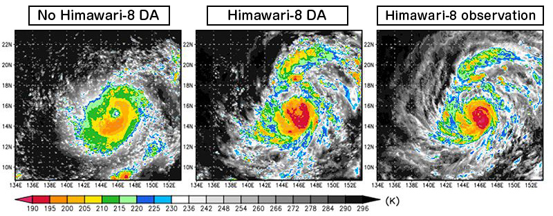
Left is without assimilation of Himawari-8 data. Center is with assimilation of Himawari-8 data. Right is actual observation by Himawari-8. By assimilating infrared luminance observation data of Himawari-8, the detailed structure of actual typhoon that was observed was reproduced.
Figure 2. Forecast for river flow volume on September 9, 2015.
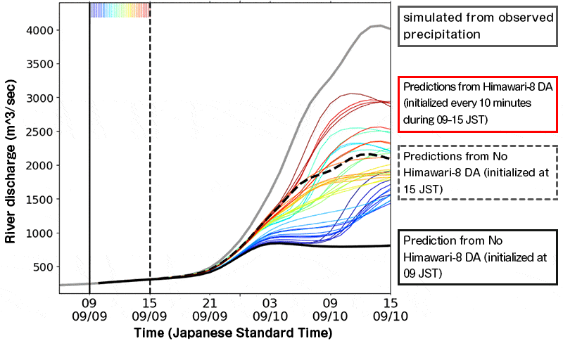
With traditional observation made every six hours, river flow volume forecast can only be updated every six hours (Black line and black dashed line in Figure). On the other hand, if Himawari-8 that makes observation every 10 minutes could be fully utilized, rain and river flow volume could be updated every 10 minutes (Colored lines; closer to red means later initial time). By updating forecast frequently, flood risk could be captured with a longer lead time. All data used the numerical weather forecast model of RIKEN and data assimilation system.
Figure 3. An example of simulation for torrential rain by “big data assimilation”.
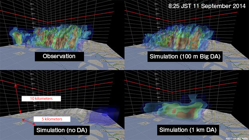
The 3D rain distribution observed every 30 seconds with resolution of 100 m by the phased array weather radar and high-precision simulation with resolution of 100 m are combined to reproduce the condition inside of cumulonimbus cloud in detail. Red is where the rain was heaviest. The map data were provided by the Geospatial Survey Institute of Japan.
Application to the field of environment and fisheries
We aim to establish revolutionary and next-generation weather forecast by capturing risks of heavy rain and flood early by effectively using forecast data obtained from Himawari-8 and PAWR. In terms of torrential rains, we aim to improve the precision to the level where 30-minute forecast could be output every 30 seconds. By also solving technological and social issues such as disaster prevention system, we believe that we can also contribute to the reduction of weather-related disasters.
Data assimilation that combines observed values and simulation may be applied in various fields beyond meteorology. For example, in a simulation of increasing and decreasing forest coverage using satellite data, images captured by satellites are used to calculate the area of leaves, which is combined with predicted values for each tree as observed value. In this manner, increase and decrease in forest coverage could be predicted with high precision. Furthermore, it could be used in fisheries by predicting, for example, ecological behaviors and red tides.